F.P. Report
KARACHI: Federal Minister for Climate Change Sherry Rehman confirmed that Karachi has become safe as the mighty Biparjoy Cyclone has slightly changed its way and now will hit the Kati Bandar on Thursday, June 15 at 11 am.
The minister addressed a press conference in Islamabad and appealed to the citizens of Karachi and other shore areas to avoid any disaster tourism and keep away from any unnecessary mobilization.
Sherry said gusts of up to 60 knots are expected by tomorrow (Thursday) and all commercial flights in Karachi will be grounded until 30 knots are reached by tonight before landfall.
The climate change minister said up to 300 millimetres of rain is possible and there may be some areas where it is not possible for people to stay even in relief camps.
Minister Sherry said there are 10 relief camps in Keti Bandar and 13 in Sajawal and different departments are continuing their rescue for in these areas.
Sherry called the people that they should avoid going to the beach to make just TikTok clips as it is highly risky for them and their family members and friends. She said, ‘It is not the time for disaster tourism.’
She advised the citizens of the urban areas that they should secure solar panels and exposed wires and stay in the middle of the houses away from windows.
She advised the citizens of Karachi and other shore areas that they should cover motorcycles and vehicles and store candles and lanterns in homes to use in case of power outages.
She advised the people that they should keep emergency kits at home with charged mobile phones and other electric devices.
She said those who have been sent to safe places are requested to take measures for their protection and don’t go out on their own and walk when guessing the weather is clear and must wait for instructions from PDMA and concerned authorities.
The climate change minister informed the media that the Prime Minister’s Monsoon and Cyclone Relief Fund has been established.
She said the ministries of Climate Change, Power, Maritime, Defence, Health, NIH, PTA, PEMRA, SPARCO, CAA, and PMD were working with them.
Earlier today, channel 24 reported that Cyclone Biperjoy is moving rapidly and it is a few hundred kilometres away from Keti Bandar and Karachi. However, the storm which has been categorized as a Very Severe Cyclonic Storm (VSCS) has started changing its direction.
For the last two days, the cyclone was tracked moving northward, but now the storm has curved towards the northeast. There lies a coastal belt dotted by Sindh villages on this track. The cyclone could have inundated the Sindh villages including Kharo Chan, Ghora Bari, Badin and Thatta.
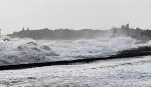
The impact of the storm began to appear on the Seaview in Karachi as sea waves started breaking over the protective embankment during the day.
During normal conditions, the water stays several feet away from the protective embankment, the waves can increase further as the storm approaches.
According to the Pakistan Metrological Department, under the existing upper-level steering winds, the VSCS “Biparjoy” started to recurve North-northeastward and likely cross between Keti Bandar (Southeast Sindh) and Indian Gujarat coast on 15 June evening as a Very Severe Cyclonic Storm (VSCS) with packing winds of 100-120 Km/hour gusting 140 km/hour.
However, the intensity of Cyclone Biperjoy has started to decrease. The situation is not dangerous in Karachi.
According to the new PMD alert, “The cyclone over northeast Arabian Sea moved north-northeastward during last 6 hours, and now lies at a distance of about 370km south- southwest of Karachi, 355km south-southwest Thatta and 290km south-southwest of Keti Bandar. Maximum sustained surface winds are 150-160 Km/hour, gusts 180 Km/hour around the system center and sea conditions being phenomenal around the system center with maximum wave height 30 feet. The favorable environmental conditions (sea surface temperature of 29-30°C, low vertical wind shear & upper-level divergence) are in support to sustain its strength through the forecast period.”
The storm will pass through Keti Bandar and Indian Gujarat after staying in the north in the afternoon of June 15.
There is a possibility of light and moderate rain in the city today, and heavy rains are expected during the next two days.
The cyclone is likely to make a landfall between Keti Bandar in Sindh and Kutch in Indian Gujarat tomorrow evening.
While watching its current trajectory, it could be predicted that the cyclonic storm is likely to cause widespread wind/dust storms, as well as thundershowers in Thatta, Sujawal, Badin, Tharparker, Mirpurkhas and Umerkot districts until Friday. These may be accompanied by squally winds of up to 120kmph.
Karachi, Hyderabad, Tando Muhammad Khan, Tando Allayar, Shaheed Benazirabad and Sanghar are likely to be hit by similar weather, along with squally winds of 60-80kmph, between today and Thursday.
Both Pakistan and India have spurred their efforts to evacuate people from their coastal areas.
The NDMA said that the concerned departments are on high alert considering the progress and possible effects of Cyclone Biperjoy.
The NDMA urged the people living in coastal areas to follow the instructions of the local administration.
Keti Bandar safety barrier broken down
The effects of the approaching Cyclone Biperjoy began to appear in Thatta as rain along with strong wind started pounding Keti Bandar and adjoining areas.
The sea dykes near Keti Bandar have weakened. Half of the Keti Bandar safety barrier has been broken down, leaving the city in danger of drowning. Though the situation is alarming, but the officials of revenue administration are still missing.
There are still 100 people present in the islands of Kharon Chan Hajamaro and Creaks Atharki.
Nineteen percent population of Thatta has not yet been evacuated whose lives have been seriously threatened.
Evacuation of citizens from Sindh coastal areas continues
Evacuation of people from coastal cities continued overnight in anticipation of the storm. 13,000 population of Keti Bandar is at risk. Authorities evacuated 3,000 people overnight.
5,000 population of Ghora Bari is at risk while 100 people have been shifted to safer places. 4,000 population of Shaheed Fazal Rahu is threatened by cyclone, out of which 3,000 evacuated.
Badin’s 2,500 population is at risk, of which 540 have so far have been shifted to safer places. Shahbandar’s 5000 population is at risk while 90 people were evacuated overnight. Jati’s 10,000 population is facing threat, and 100 people have been evacuated overnight. Kharo Chan’s 1,300 population is under threat, of which 6 people have been shifted overnight.
So far, 6,836 people out of 40,800 have been evacuated and the shifting of the remaining people will continue throughout the day.
The administration will also continue to relocate the people of Thatta, Badin and Sujawal districts.
Sindh Chief Minister Murad Ali Shah said that people do not want to leave their homes but there is no other option but to shift them to a safer place. The Chief Minister appealed to the people to cooperate with the administration and move to safer places.
100,000 evacuated as cyclone threatens India and Pakistan
AFP says more than 100,000 people have been evacuated from the path of a fierce cyclone heading towards India and Pakistan, with forecasters warning Wednesday it could devastate homes and tear down power lines.
Powerful winds, storm surges and lashing rains were forecast to hammer a 325-kilometre (200-mile) stretch of coast between Mandvi in India’s Gujarat state and Karachi in Pakistan.
India’s Meteorological Department predicted the storm will hit near the Indian port of Jakhau late Thursday, warning of “total destruction” of traditional mud and straw thatched homes.
At sea, winds were already gusting at speeds up to 180 kilometres per hour (112 miles per hour), forecasters said.
By the time it makes landfall wind speeds are predicted to reach 125-135 kilometres per hour, with gusts up to 150 kilometres per hour.
“Over 47,000 people have been evacuated from coastal and low-lying areas to shelter,” said C.C. Patel, an official in charge of relief operations in Indian Gujarat.
More were expected to be moved inland throughout Wednesday.
India’s meteorologists warned of the potential for “widespread damage”, including destruction of crops, “bending or uprooting of power and communication poles” and disruption of railways and roads.
In the beach town of Mandvi, streets were mostly empty Wednesday with just a few hungry stray dogs roaming abandoned beach shacks, next to large, rolling waves under strong gusts and grey skies.
The Gujarat state government released photos showing lines of residents clutching small bags of belongings and boarding buses inland away from areas predicted to be worst hit.
Fishing has also been suspended along the Gujarat coast with conditions expected to escalate from “rough to very rough” on Wednesday to “high to phenomenal”.
“There could be flooding in some low-lying areas and we are prepared to handle that,” Mohsen Shahedi, a senior official from India’s National Disaster Response Force, told reporters.
Five people have already been killed in India including two children who were crushed when a wall collapsed, while a woman was hit by a falling tree when riding a motorbike.
‘High to phenomenal’
Pakistan’s Climate Change Minister Sherry Rehman said Wednesday that 62,000 people had been evacuated from the country’s southeastern coastline, with 75 relief camps set up at schools and colleges.
She said fishermen had been warned to stay off the water and small aircraft were grounded, while urban flooding was possible in the megacity of Karachi, home to around 20 million people.
“We are following a policy of caution rather than wait and see,” she told reporters in Islamabad. “Our first priority is saving lives.”
The PMD forecast gusts up to 140 kilometres per hour in Sindh, accompanied by a storm surge reaching 3.5 metres (11.5 feet).
Fresh troops of Pakistan Army deployed
A high-level meeting was held under the chair of Sindh chief minister to take precautionary measures in the face of approaching Cyclone Biperjoy.
The meeting was attended by DG Rangers Sindh, GOC Hyderabad Garrison and other relevant officers. A strategy was formulated and fresh troops of Pakistan Army were deployed to deal with emergency situation.
The Pakistan Army has relayed instructions to all garrisons, directing them to provide full assistance on emergency basis to people and rescue them in view of the hurricane.
Heavy contingents of the Pakistan Army have been dispatched from Hyderabad, Badin and Malir Cantt to assist the civil administration.
In total, about 90,000 civilians are to be evacuated from the coastal areas of Thatta, Sujawal and Badin to safer places.
More than 40 buildings in Karachi have also been identified for immediate evacuation in view of the dangers.
The Pakistan Army will play its full role in the front line to prevent all kinds of damage and provide full assistance to the people.
Karachi sea level rises
Due to strong winds, the water level in the sea has also risen. Water has entered the temporary shelters built at Ibrahim Haidari, DHA Golf Club and Hawke’s Bay.
Sindh govt cancels holidays of district officers, employees
In view of the effects of the cyclone, the Sindh government has canceled the holidays of all district officers and employees and has ordered the establishment of control rooms in the coastal districts including Karachi.
In addition, the order has also been made to remove materials from the under construction buildings.
The health department and KMC hospitals have been put on high alert while DMCs and cantonments have been instructed to remove the billboards. Evacuation of residents from dangerous buildings and shifting to safer places and all deputy commissioners have been instructed to set up relief camps.
The Sindh government has issued directives to install dewatering pumps.
It directed the district administration, Rangers and coastguards to ensure the implementation of Section 144 and take safety measures accordingly.
Yesterday, Prime Minister Shehbaz Sharif chaired a meeting to review the preparedness ahead of the possible impact of the Biparjoy cyclone. He asked the Sindh government, NDMA and other organizations to ensure the establishment of mobile hospitals in coastal areas and provide adequate emergency medical assistance there.
He said in view of the storm, special arrangements of clean drinking water and food should be made at the camps of displaced persons.
The World Health Organization (WHO) also mobilized health sector partners for initiating a preparedness and response plan for Tropical Cyclone Biparjoy.
According to WHO, currently, Pakistan is facing the threat of Tropical Cyclone Biparjoy, and due to the threat people living along the coastal areas in Sindh, especially are being evacuated to safer places.
WHO Representative in Pakistan, Dr Palitha Mahipala chaired an Incident Management Support Team (IMST) and health sector partners meeting on Tuesday in the wake of severe cyclone Biparjoy and issued immediate directives for preparations for Tropical Cyclone Biparjoy emergency preparedness and response measures.
Rain in other parts of country
Windstorm, rain and hailstorm lashed different areas in Punjab, Kashmir and Khyber Pakhtunkhwa today.
Dusty wind hit Lahore and rain was poured in the morning today.
Gusty winds and rain also lashed Sheikhupura, Gujranwala, Gujarat and Jhelum.
Heavy rains pounded different areas of Azad Kashmir and Khyber Pakhtunkhwa.
Meteorological Department has predicted more rains today.
According to the PMD weather report today, Kashmir, Upper Punjab, Islamabad, Gilgit-Baltistan, Khyber Pakhtunkhwa, East and South Balochistan and Central Sindh will witness windy/dusty winds and thundershowers and a few rains. There are chances of hailstorm too at some places.
Lower Sindh is likely to experience strong gale/dusty winds and thundershowers and heavy rain at few places.
There is a possibility of thunderstorms in the plain districts of the country, the PMD alerted.
Cyclones — the equivalent of hurricanes in the North Atlantic or typhoons in the Northwest Pacific — are a regular and deadly menace on the coast of the northern Indian Ocean, where tens of millions of people live.
Scientists have warned that storms are becoming more powerful as the world gets warmer with climate change.
Courtesy: (24News)